Land
How to Read a Topographic Map: Researching Your Land
Feb 2, 2026 | Hall and Hall

Reading the Shape of the Land
A topographic map is a way of translating the land into lines and symbols that show elevation, slope, and natural features. Rather than a flat image, it gives a sense of how the ground actually rises and falls across a property.
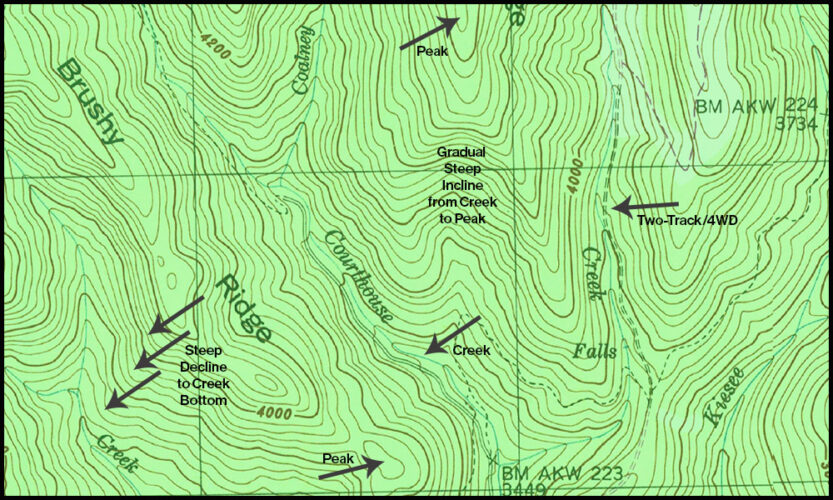
Understanding Contour Lines and Spacing
Contour lines help inform access and usability, assisting in management planning. Contour lines provide a three-dimensional view of the land by indicating the steepness of the terrain. Tighter lines signify steeper terrain. Widely spaced lines depict gentler terrain.
Recognizing Key Topographic Features
Contour lines can also illustrate the shape of the terrain. Groups of concentric circles can indicate a peak on a mountain. “Index lines” are used every fifth contour line, and are thicker and list the elevation. The elevation change between one contour line is always the same within the same map.
Calculate Distance and Access
Help plan routes for gathering cattle, hiking and hunting. Access across gentle terrain will change significantly if the equal distance is applied to steep terrain with draws and water crossings.
Topographic Maps Matter When Evaluating Land
Today’s maps are created with a large amount of data built in to help a user access all sorts of knowledge before setting boots on the ground. Water flows, vegetation, wells, fence lines, buildings and trails are just a few of the features available in our digital maps provided with a listing.
Why This Matters in Practical Application
Being able to read a topographic map helps landowners and buyers understand how a property functions. Slope affects access, grazing, water movement, and where improvements make sense. A topo map doesn’t replace walking the land, but it gives valuable insight before boots ever hit the ground.
Seeing the Land More Clearly
Topographic maps help turn lines on paper into a mental picture of the land. With a little practice, they become a useful tool for understanding terrain, planning use, and asking better questions about a property.


